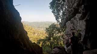
Doi Chiang Dao
(Recommended November to March) Although it is the third highest mountain in Thailand, it is considered by many to be the most dramatic with its craggy peaks and spectacular 360-degree views. The Chiang Dao mountain range and an 'ocean of mist' are on one side, and the far end of the Doi Inthanon range on the other, the highest in Thailand - all of which descends into pristine green valleys beneath. If you are reasonably fit the hike to the summit is achievable by yourself in a single day (5-8 hours round-trip depending on fitness and the conditions). You need to get to the Pang Wua starting point which you can do by rented motorbike. To get here, go past the Chiang Dao cave, pay your 200B per person entrance fee at the National Park checkpoint, and then it’s about 8km down to the Pang Wua car park. The trail to the summit is well marked but in Thai. At the first T-intersection going up head left, when you come back down, head right to take you back to the car park. Locals should be able to point you in the right direction if you struggle anywhere else. Your second option is to opt for a package trip with one of the local tour outfits, such as the Nest or Malee's guesthouses, who have long established relations with the local mountain tour guides and will arrange everything for you. A typical day tour is around 3300B/1900B per person for 1pax/2pax decreasing down to 1000B per person if over five people, which includes a guide, entrance and transfer to Pang Wua from Chiang Dao. An overnight tour is around 4500B/3050 per person for 1pax/2pax which includes additional food, a porter and camping gear. The advantage of doing an overnight trek is you get to see the spectacular sunset and sunrise, highly recommended! If you are based in Chiang Mai city and you want to make the trek, there are many trekking companies in town that can arrange a two-day hike which can also include an overnight stay at a hill tribe village. There are no tourist facilities on the mountain, so ensure you have enough food and water. The campsite is just below the summit, and it gets quite cold (below 10°C) at night, so take some warm clothes. When you reach the summit, as well as taking in the stunning panoramic views you will see that the entire area is blaze of rare highland flowers, birds and butterflies, many of which are only to be found in this area. The wild plants that grow here are Himalayan plants which have mutated into a vast array of unique, colourful local plants. Decent of the mountain is usually via the trail near Ban Tham which is rather steep, but it reduces the time and distance for the descent. Getting There - Go to the Park entrance of Pha Daeng National Park next to the wildlife sanctuary HQ, where you can arrange permits and transport to take you to the base of the mountain.

Chiang Dao


Chiang Dao